Historic Flooding in Yellowstone National Park
By: Shannon Kronz, EIT, Brown, and Caldwell
The beginning of the 2022 water year led to drought conditions throughout the Pacific Northwest region. In April, southwest Montana and surrounding areas experienced higher than average precipitation, which led to increased snowpack in the Yellowstone River watershed. A few months later, between June 10 and13, an atmospheric river brought 0.8-5 inches of rain to the Absaroka and Beartooth mountain ranges, located northeast of Yellowstone. The significant amount of rain from the atmospheric river also caused the snowpack to melt, which, combined, was equivalent to 4-9 inches of rain. The large quantity of precipitation caused historic flooding downstream on the Yellowstone River [1].
A USGS stream gauge on the Yellowstone River located in Corwin Springs, approximately 8 miles north of Yellowstone National Park, measured a river stage of 13.88 ft [2]. The river stage broke the previous record of 11.5 ft. set back in 1918. The maximum flow rate recorded on the Yellowstone River during the flooding reached 51,400 cubic ft. per second (cfs) [1]. The peak stream flow recorded in Corwin Springs and at another stream gauge in Livingston was higher than the 1-in-500 year flood event. Provisional stream flow data from the Yellowstone River in Billings measured flood conditions between the 1-in-100 and 1-in-500 flood event [3].
The flooding caused the National Park to shut down all entrances on June 13. Bridges, roads, and houses in surrounding communities were destroyed by the floodwaters. The roadway connecting Gardiner and the Yellowstone National Park headquarters was washed out. Flooding also caused power outages and compromised drinking water supplies in the area. The damage is expected to take years to repair [1].
The flooding is also expected to reshape the landscape surrounding the Yellowstone River. Although the Yellowstone River caused erosion on the banks, new sediment from decaying trees and transported sediment from upstream banks will eventually create new sandbars and embankments.
The historic flood provides the opportunity for riverside trees such as willows and cottonwoods to spread their seeds and take root in the new embankments. Both willows and cottonwoods need wet, sandy soil conditions to release their seeds. Currently, most of the cottonwood trees located in Yellowstone National Park (1.36 million of the 1.37 million cottonwood trees along the Lamar and Gardner Rivers and Soda Butte Creek) took root during a series of floods between 1995 and 1997. According to National Geographic, many researchers and conservationists remain optimistic that this year’s floods will lead to the growth of cottonwood trees along the rivers in and around Yellowstone National Park [4].
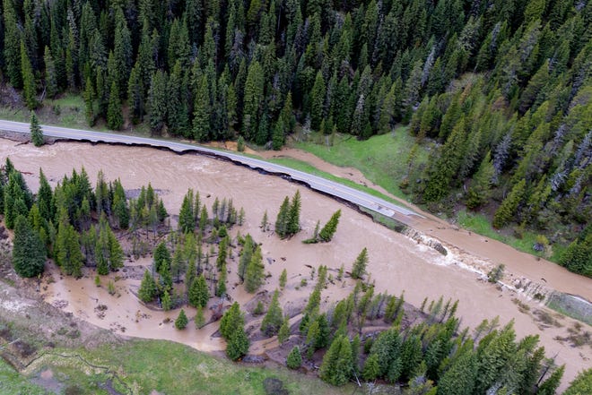
The North Entrance to Yellowstone National Park on June 13, 2022 [5]
References
[1] https://earthobservatory.nasa.gov/images/150010/catastrophic-flooding-in-yellowstone
[2] Yellowstone River at Corwin Springs MT - USGS Water Data for the Nation
[3] https://wyofile.com/historic-rain-event-floods-wrecks-yellowstone/
[4] https://www.nationalgeographic.com/environment/article/historic-yellowstone-flooding-brings-renewal-despite-destruction?loggedin=true
[5] https://www.usatoday.com/story/travel/experience/national-parks/2022/06/15/yellowstone-national-park-flooding-damages-visitors-info/7632567001/